
Links
This page provides Links to useful Organisations and Information
Use the options below to filter the list by category, then click/tap the title to open it and get information about the organisation, together with useful links.
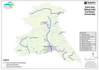
The Catchment-Based Approach (CaBA) Partnership for the Hull and East Riding management catchment was established in 2014. It is hosted by the Yorkshire Wildlife Trust with support from the East Yorkshire Rivers Trust as Joint Host. They are joined on the partnership by twelve other organisations that take an interest in the management and enhancement of the water bodies in the Hull and East Riding area. West Wolds Slow the Slow is affiliated with HERCP.
Useful References: Catchment Plan 2017 (PDF)
The Environment Agency is a non-departmental public body, established in 1995 and sponsored by the United Kingdom government's Department for Environment, Food and Rural Affairs, with responsibilities relating to the protection and enhancement of the environment in England.
Useful References: (DEFRA) The Enablers and Barriers to the Delivery of Natural Flood Management Projects (PDF) April 2020
(EA) Working with Natural Processes to reduce flood risk (PDF) 2017The East Yorkshire Rivers Trust (EYRT) is a registered charity which aims to: protect the important habitats of the River Hull and River Derwent by working with others to enhance the conservation status of these important river systems; educate and assist in developing projects to achieve improvements in habitat; support and fund scientific surveys on the streams to identify problem areas.
As a registered charity, EYRT receives funding on behalf of WWSTF to help us develop our projects.
The ERYC flood risk strategy team is responsible for implementing and managing the council’s duties as the Lead Local Flood Authority, coordinating and overseeing the council’s approach to managing and reducing the risk of flooding to residents, business and infrastructure in the East Riding, including investment in coastal defences.
Yorkshire Water is responsible for both water supply and waste water treatment and disposal in Yorkshire. It brings a great deal of expertise to WWSTF in the form of the Agricultural innovation, the Drainage and Wastewater Management Plan (DWMP) as well as operational aspects, which both impact upon, and are impacted by, surface water.
Useful References: Good Soil Guide
'Community under one canopy'. Humber Forest is a partnership which helps communities, farmers, landowners, and businesses to plant trees in the easiest and most effective way possible, at no cost. WWSTF is working with Humber Forest to encourage planting of trees wherever practical, to help reduce flooding and improve water quality.
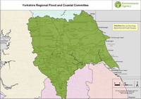
The Regional Flood and Coastal Committee (RFCC) is a committee established by the Environment Agency under the Flood and Water Management Act 2010 that brings together members appointed by Lead Local Flood Authorities (LLFAs) and independent members with relevant experience for 3 purposes: to ensure there are coherent plans for identifying, communicating and managing flood and coastal erosion risks across catchments and shorelines; to encourage efficient, targeted and risk-based investment in flood and coastal erosion risk management that represents value for money and benefits local communities; to provide a link between the Environment Agency, LLFAs, other risk management authorities, and other relevant bodies to build understanding of flood and coastal erosion risks in its area.

Brantingham sits on the edge of the Wolds, east of the A63. Whilst is has not experienced serious flooding, storm water from Brantingham Parish flows into Ellerker and, as a result, Brantingham is an important part of the WWSTF partnership. Mill Beck flows to the Humber along the southern edge of Brantingham Parish.
Based in Calderdale, Slow The Flow is a charity working to advance the education of the public in Natural Flood Management, Sustainable Drainage Systems and other renewable methods of managing the environment, including the exploration of alternative practices which safeguard the natural environment and its resources in a manner which best fits the specifics of a local geography.
'Slow the Flow' is the inspiration for 'West Wolds Slow the Flow'. They are a hugely energetic group, and the website carries a lot of useful information. WWSTF may achieve its aims in a different way, but the guiding principles will be the same.
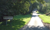
Village Link is published and distributed free of charge to over 1000 homes in the East Yorkshire villages of Hotham, Everthorpe and North Cave. It was set up as a Millennium project in 2000 to continue and extend the functions of the then retiring vicar's parish newsletter. Whilst it is now a community - rather than a church - newsletter, it serves the same parishes. It provides regular updates on the WWSTF initiative.
The Pang Valley Flood Forum was set up in January 2013 as a joint initiative by West Berkshire Council, the Environment Agency and Thames Water. The aim of the Forum is to act as the principal consultation body to the three agencies on flooding and drainage issues in the Pang Valley.
It works with the agencies to oversee and monitor the delivery of flood risk mitigation works (Actions) within its Flood Risk Management Plan. Everyone who may be affected by or has a role to play in the management of flooding has the opportunity to influence or contribute to the development of new Actions.
WSFG exists to: exchange information among members on issues in our own catchments to improve how we help communities prepare for/recover from flooding; act as a point of contact between West Somerset communities and Flood Risk Management Authorities; raise awareness of flooding in West Somerset, both within the district and beyond; make sure that West Somerset is not forgotten in the allocation of resources to address flooding.
This is a great partnership website with some really useful information and documents, such as 'SIMPLE SUDS FOR LOCAL PEOPLE'.
Yorkshire Wildlife Trust is a charity dedicated to conserving, protecting and restoring wildlife and wild places in Yorkshire.
"Our vision is for a Yorkshire that is abundant in wildlife, with more people having a genuine and meaningful connection with nature." YWT was established as a charity in 1946, and is part of The Wildlife Trusts movement. It looks after over 100 nature reserves right across Yorkshire, and is involved in hundreds of other conservation-related projects.
2B Landscape Consultancy is an East Yorkshire-based landscape architectural consultancy and is the driving force behind West Wolds Slow the Flow. 2B's understanding of Sustainable Drainage and Natural Flood Management, its holistic view of design in the landscape, and its work with a wide range of organisations, informs the vision of a catchment-based, multi-functional, and partnership-based approach to flood mitigation and environmental improvement.

What does the Government have to say about Natural Flood Management?
"Natural flood management works best when a 'catchment based approach' is taken, where a plan is developed to manage the flow of water along the whole length of a river catchment from its source to sea. This way, natural processes can be used upstream and on the coast to compliment engineered flood defences – such as walls and weirs – in populated areas. Natural flood management not only reduces flood risk it can also achieve multiple benefits for people and wildlife, helping restore habitats, improve water quality and helping make catchments more resilient to the impacts of climate change."